Two Worlds:Antaloor: Difference between revisions
Fandom Two Worlds>Matt113 No edit summary |
m (Text replacement - "Tharbakin" to "Tharbakin Town") |
||
| (34 intermediate revisions by 10 users not shown) | |||
| Line 1: | Line 1: | ||
{{For|the lore page|Lore:Antaloor}} | |||
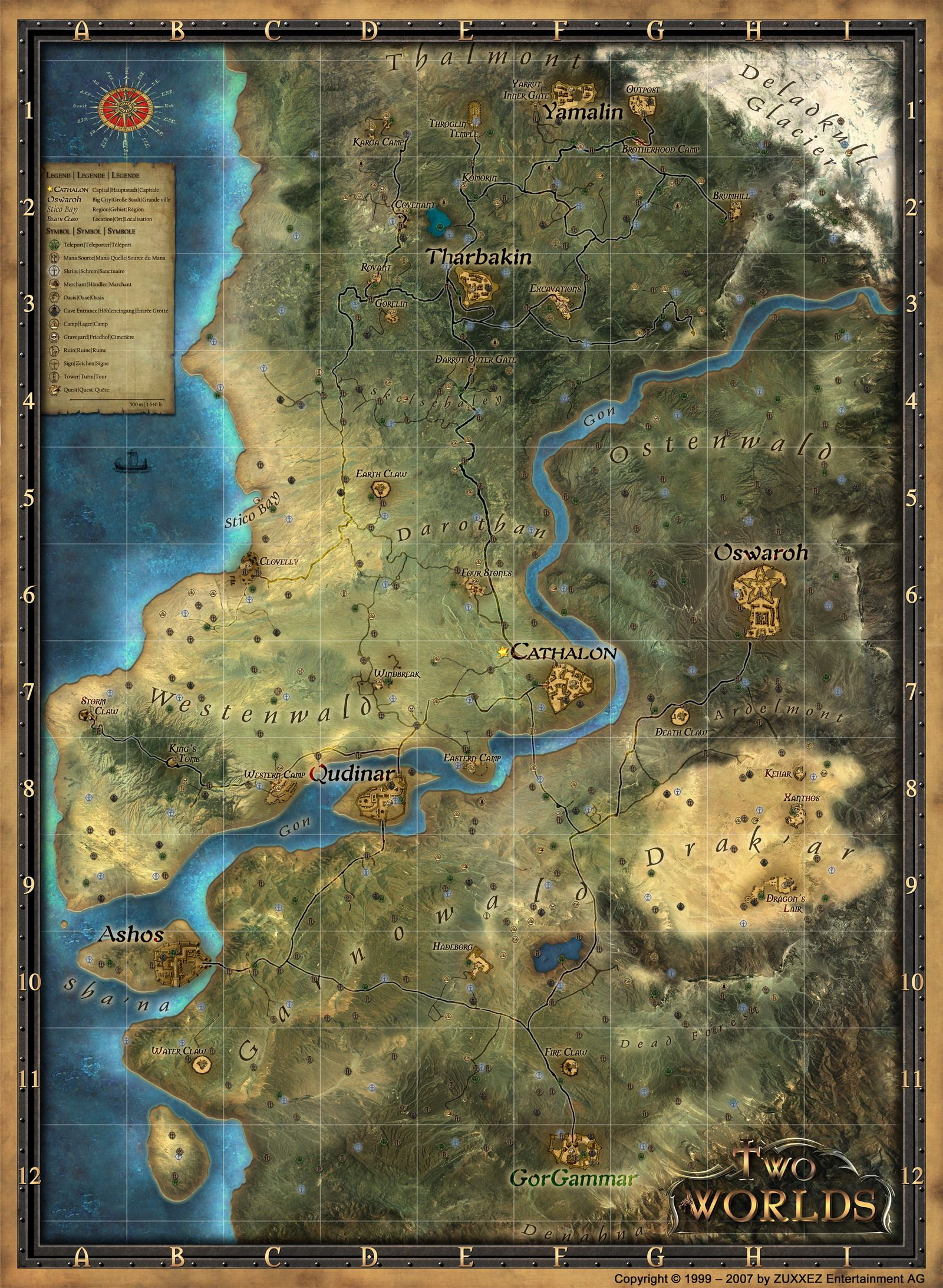
'''Antaloor''' is the name of the world {{Meta|Two Worlds}} is set in. Fans refer to it as "The West Continent", based on a {{Lore|Antaloor Globe Map|non-canon Two Worlds II Globe Map}}. | |||
== | ==Northern Antaloor== | ||
The continent is divided into a number of regions, other than the north and south, which are separated by the {{TwoWorlds|River Gon}}. The north is much more hospitable than the south, due to the {{TwoWorlds|Kingdom of Cathalon}} being almost completely situated there. | |||
In the north lies the heavily forested, mountainous province of {{TwoWorlds|Thalmont}}. The city of {{TwoWorlds|Tharbakin Town}}, which serves as the seat of government for the region, is centrally located, with roads leading to every major settlement. Surrounding Thalmont are a number of smaller villages. To the west lie the villages of {{TwoWorlds|Rovant Village}} and {{TwoWorlds|Gorelin}}, and to the northwest lies {{TwoWorlds|Covengor}},<ref group="n">This is mistakenly named Covenant on the map.</ref> and to the north lies {{TwoWorlds|Komorin Village}}. | |||
To the far north is the Dwarven city of {{TwoWorlds|Yamalin}}, which is inaccessible to all {{TwoWorlds|Humans}}, and protected by the {{TwoWorlds|Yarrut Inner Gate}}. To the northeast is the {{TwoWorlds|Deladkull Glacier}}. In the middle of northern Antaloor is {{TwoWorlds|Darothan}}, a forested region devoid of any settlements. To the southwest is {{TwoWorlds|Westenwald}}. This lightly forested region, complete with beautiful meadows, and a sandy coast. Unfortunately, Westenwald is also more dangerous than Thalmont. Westenwald is home to the two cities of {{TwoWorlds|Qudinaar}}, and {{TwoWorlds|Cathalon}}, the capital of the region that it is named after. It also houses the villages of {{TwoWorlds|Windbreak Village}}, {{TwoWorlds|Four Stones Village}} and {{TwoWorlds|Clovelly}}. | |||
==Southern Antaloor== | |||
South of the River Gon is the slightly hospitable, but mostly desolate, {{TwoWorlds|Garnowald}}. To the northwest is the bamboo forest surrounding {{TwoWorlds|Ashos}}, an important trade port in Antaloor. To the southeast is the {{TwoWorlds|Dead Forest}}, a burned-out area home to none but monsters. To the east is the {{TwoWorlds|Drak`ar Desert}}. This desert is home to the two small settlements of {{TwoWorlds|Xanthos}} and {{TwoWorlds|Kahar}}, the only friendly areas in the dangerous desert. To the very north is the {{TwoWorlds|Ostenwald}}, home to the burned down, ancient, desolate city of {{TwoWorlds|Oswaroth}}. Due to poisonous mist surrounding the city though, only tainted creatures, undead, {{TwoWorlds|Demon}}s and {{TwoWorlds|Stone Dragon}}s can be found there. Recent maps of Antaloor don't show Oswaroth on the map, with only a blank spot in its space. | |||
==Gallery== | |||
<gallery> | |||
Two Worlds - Antaloor.jpg | World Map. | |||
</gallery> | |||
<!-- | |||
==Trivia== | |||
* | |||
--> | |||
==In Other Languages== | |||
{{In Other Languages | |||
| en = Antaloor | |||
| fr = | |||
| fr_us = | |||
| es = | |||
| es_us = | |||
| de = | |||
| it = | |||
| ja = | |||
| ko = | |||
| ru = | |||
| zh = | |||
| td = | |||
| pt = | |||
| pt_br = | |||
| pl = | |||
}} | |||
==See Also== | |||
{{Two Worlds Locations Navbox}} | |||
==Notes== | |||
<references group="n" /> | |||
[[Category:Two Worlds Locations]] | |||
Latest revision as of 00:57, January 3, 2025
Antaloor is the name of the world Two Worlds is set in. Fans refer to it as "The West Continent", based on a non-canon Two Worlds II Globe Map.
Northern Antaloor
The continent is divided into a number of regions, other than the north and south, which are separated by the River Gon. The north is much more hospitable than the south, due to the Kingdom of Cathalon being almost completely situated there.
In the north lies the heavily forested, mountainous province of Thalmont. The city of Tharbakin Town, which serves as the seat of government for the region, is centrally located, with roads leading to every major settlement. Surrounding Thalmont are a number of smaller villages. To the west lie the villages of Rovant Village and Gorelin, and to the northwest lies Covengor,[n 1] and to the north lies Komorin Village.
To the far north is the Dwarven city of Yamalin, which is inaccessible to all Humans, and protected by the Yarrut Inner Gate. To the northeast is the Deladkull Glacier. In the middle of northern Antaloor is Darothan, a forested region devoid of any settlements. To the southwest is Westenwald. This lightly forested region, complete with beautiful meadows, and a sandy coast. Unfortunately, Westenwald is also more dangerous than Thalmont. Westenwald is home to the two cities of Qudinaar, and Cathalon, the capital of the region that it is named after. It also houses the villages of Windbreak Village, Four Stones Village and Clovelly.
Southern Antaloor
South of the River Gon is the slightly hospitable, but mostly desolate, Garnowald. To the northwest is the bamboo forest surrounding Ashos, an important trade port in Antaloor. To the southeast is the Dead Forest, a burned-out area home to none but monsters. To the east is the Drak`ar Desert. This desert is home to the two small settlements of Xanthos and Kahar, the only friendly areas in the dangerous desert. To the very north is the Ostenwald, home to the burned down, ancient, desolate city of Oswaroth. Due to poisonous mist surrounding the city though, only tainted creatures, undead, Demons and Stone Dragons can be found there. Recent maps of Antaloor don't show Oswaroth on the map, with only a blank spot in its space.
Gallery
World Map.

In Other Languages
| Language | Name | ||
|---|---|---|---|
| English | UK |
Antaloor | |
See Also
Notes
- ↑ This is mistakenly named Covenant on the map.